Intense Weather Closes In On Western North American Coast
Ocean waves could top 60 feet due to hurricane-force winds.

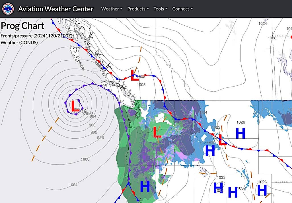
A low-pressure system currently west of Oregon and Washington will undergo extremely rapid deepening over the next few days leading to close to, if not the lowest, surface pressure observed in this geographic area at this time of year. Sustained hurricane-force winds over the open ocean are expected to generate ocean waves as high as 60+ feet. Credit Aviation Weather Center
Airports in Canada and the Pacific Northwest of the U.S. are bracing for a long round of extreme weather expected starting tonight over a wide swath of western North America. The area has seen substantially dry conditions for months. But a very slow-moving “atmospheric river” is moving in, expected to bring high winds and torrential rains. According to the website Weather West, the expected flash flooding will be worse, given how wildfires earlier this year (more than 1 million acres burned throughout California) have cleared trees and other vegetation.
The rapid shift from dry to wet weather is described as “hydrodynamic whiplash” and is expected to be extreme. A low-pressure system off the coast of Oregon is almost certain to see an extremely rapid deepening—dropping to near or below 940 millibars (mb) at the center. The result is known as a “bomb cyclone,” defined as producing a pressure drop of 18 to 20 mb per 24-hour period. This system could drop by as much as 70 mb, according to experts, resulting in hurricane-force sustained winds of up to 90 mph. This developing bomb cyclone has the potential to be the most extreme in history.
The resulting atmospheric river is predicted to stall over Northern California for at least two to three days with successive waves of intense precipitation “firehosing” the area with intense rain. The system is expected to pick up even more moisture given unusually high water temperatures in the Pacific Ocean, where offshore waves are expected to reach as high as 60 feet.


