Transitioning Into The Backcountry
I knew we were too high and too fast coming into Atlanta, Idaho (55H), the type of backcountry airstrip that offers no go-around potential. I had blown it, but CFI…

I knew we were too high and too fast coming into Atlanta, Idaho (55H), the type of backcountry airstrip that offers no go-around potential. I had blown it, but CFI Paul Leadabrand, in the right seat, had forced me to select an abort point and departure route before we started into the pattern. It was my first serious backcountry approach/landing. My gut screamed, “Abort! Continue flying downstream and get outta here!” but Leadabrand urged me to stay with the approach perpendicular to the river valley. Ready to yell, “Your plane!” and let him make the landing work, I reluctantly continued toward the grass/dirt runway. I put it down about one-third of the way up the 2527-foot-long runway. The steepish (nearly 4 percent) slope and moderately rough surface slowed the plane to taxiing speed long before reaching the end. After pulling off the runway and stopping, Leadabrand congratulated me on a successful landing and then asked, “Were you thinking about bailing out on the base?” “Absolutely,” I replied. My first deeply visceral lesson learned on this trip—a heavy bush plane landing at 50 knots on an uphill, turf and gravel surface needs far less runway than a sporty RV touching down at 65 knots on flat pavement. This was the sort of thing I was in Idaho to learn.
We read and hear a lot about transition training in the experimental world. Insurance companies regularly demand at least a few hours with a CFI in the same or very similar make and model before issuing a policy. When my husband Paul Dye, our build partner, and I completed a Dream Tundra bush plane a few years ago, most insurance companies refused to quote because of the lack of data on the plane. Only about a score of Tundras have taken to the air throughout the world, and many of them are floatplanes. Our insurance broker finally found a company willing to accept “similar type” experience, and I did my biennial flight review in a Cessna 170 to comply with the requirement. Transitioning to the Tundra and flying it to the same places and in the same manner that I have been flying my conventional-gear RVs for the last 1500+ hours was easy. The challenge was that I wanted a bush plane to fly to places I hadn’t (and wouldn’t) take my RVs. I figured what I really needed was transition training into challenging backcountry flying.
Paul came home a few years ago (and shortly before we bought into the Tundra project) completely psyched up about his experience flying a turbocharged Kitfox in the Idaho backcountry with Paul Leadabrand of Stick & Rudder Aviation. Inspired by his enthusiasm, I held the thought that I would join Leadabrand for a few days of training once the Tundra was completed and I felt comfortable in it. The time had come to act on that plan.
Arrival Day
I arrived at Greenleaf Air Ranch about 9 a.m. after a two-plus hour flight from home. Although the airpark provides a perfectly adequate paved runway with numbers, a windsock, and parallel taxiway, it doesn’t currently appear on the charts or standard websites, like AirNav.com. So, I ferreted out the location on Google Earth and plugged in the coordinates. After a brief meet-and-greet with Leadabrand, we settled into a discussion of the Tundra specifications and flight characteristics. Since there is no factory-provided pilot’s operating manual for the Tundra, Leadabrand had to rely on my impressions and knowledge of the plane. With this information transferred to him, we developed a plan for the day. Our primary objective would be to introduce Leadabrand to the Tundra’s flight characteristics and my skills flying it. In a two-hour flight, we landed at six different fields—paved, grass, long, short, wide, and narrow— trying different approach speeds and flap settings, always searching for the keys to short- and/or soft-field landings. There was very little overt training or repetition as the objective was to explore the capabilities of the plane and pilot under different conditions and using different approaches. Nonetheless, I (and my instructor) learned a huge amount about how to fly this relatively new airplane.
Over dinner, Leadabrand briefed me on his concept of “shopping” the landing strip before attempting to land. He presented four cardinal rules for inspecting the potential site:
- Establish a “normal” circling flight about 1000 feet above the runway that allows inspection of the site and the potential obstacles. Since all landings will be uphill, a primary goal of shopping is the determination of slope and the appropriate approach direction. The procedure is done at a comfortable, stable, but relatively slow speed that we would determine in the morning.
- Determine an “abort” point—location and elevation. Many of the fields we planned to visit are one-way: One must depart in the opposite direction from arrival. Thus, the abort point might be on base instead of during the final leg.
- Determine the path of escape if the approach is aborted. Since landings will be directed upslope, a typical go-around might not work.
- Identify the departure corridor following takeoff. The low path for departure may not be evident from the ground and should be determined while shopping the field. Some variety of an extended base leg might be the best escape from an overly challenging situation. Armed with this information, the standard traffic pattern is modified to whatever degree demanded to make the approach as safe as possible.
Going Shopping
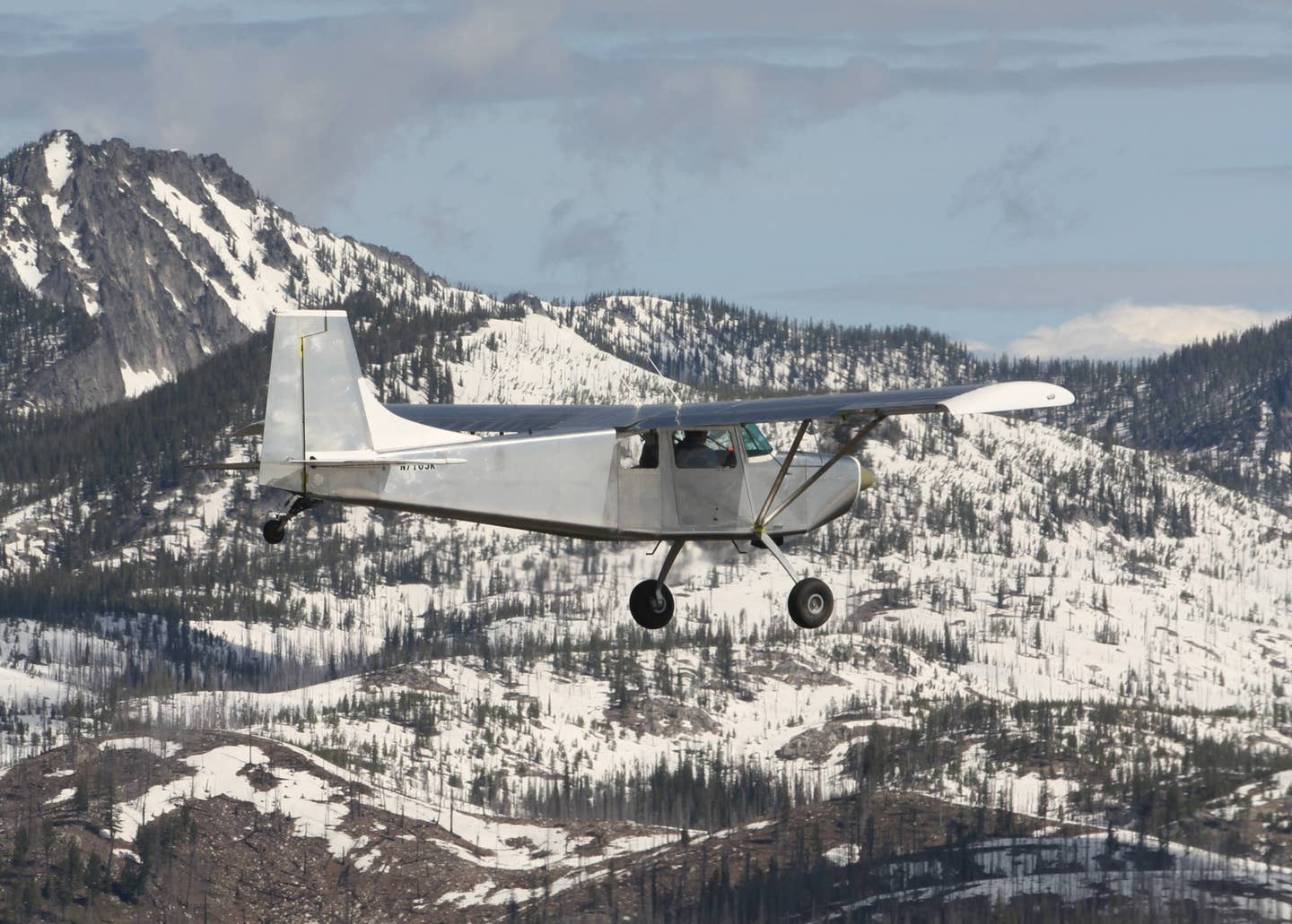
The next day brought severe CAVU (ceiling and visibility unlimited) when we met Leadabrand at the Nampa, Idaho, airport (MAN) for an early morning flight. We had spent the night in a local motel, and he had flown over in one of his Kitfoxes. After a briefing on both the general goals for the day (fly to increasingly more challenging airstrips) and the specifics of the first stop, Leadabrand and I loaded into the Tundra while Dye mounted the Kitfox to use as a chase plane and photo ship during my training.
I am a pilot first and foremost because I love the view. Some folks love the feel of flying or the perceived prestige of being a pilot, but I mostly love looking down (or, sometimes, out) at the world from our high perches. And, frankly, that passion can get in the way of piloting. Once we crossed over the Boise airspace, we started flying up the Boise River canyon, between walls of beautifully exposed, young flood basalts. While most basalt lava flows erupt from cone-shaped volcanoes and have modern analogues, like Mount St. Helens in Oregon or Mauna Loa in Hawaii, flood basalts on Earth resulted from relatively isolated, sporadic, huge eruptions that dwarf modern volcanoes, but lack a central cone. For a while, the geologist side of my brain overcame my pilot side and the trip suddenly felt like a vacation. I yearned to explore the many lava tube caves exposed by the canyon, and I found it difficult to pay attention as Leadabrand pointed out the narrow, blind side canyons that could easily sucker a pilot into a fatal trap. The distraction of spectacular geology frequently tugged at me throughout training, but the seriousness of the topic pulled my focus back to flying.
Our first stop was to be Smith Prairie, a long (5425 feet), wide (150 feet), high (4958 feet MSL), gently sloped (2 percent), gravel and grass runway in a broad valley. It seemed no more intimidating than Big Bear Airport in Southern California, where I frequently operate, albeit this runway surface was rougher and the elevation slightly lower. It was a gentle introduction to Idaho mountain flying. I noted that it would be a beautiful place to camp, complete with a toilet, picnic table, and barbeque grill. Unfortunately, a forest fire a few years ago slightly diminished the nearby beauty, but it’s still a gem.
Our party of two planes and three pilots stopped to investigate the facilities, debrief the flight, and update plans for the next two airports. Our next destination was Pine (1U9), another dirt and grass runway in a broad valley at moderate elevation. In fact, it was lower (4232 feet MSL) than my home field at Dayton, Nevada, but much shorter (2326 feet). It was all part of Leadabrand’s “easing into it” plan. Pine passed with no fanfare or problems. Once both planes had successfully landed, we departed over the adjacent reservoir and headed north. The true mountain flying beside snow-covered peaks began.
Raising the Bar
As we flew over the 2527-foot long Atlanta Airstrip to shop the field, it was clear that the bar had jumped up several notches. Carved onto a nearly 4-percent hillside of a not-so-broad canyon with high ridges immediately to the east and south, this was the type of mountain airstrip one hears about—an airstrip with no possible go-around. Shopping at the first two airports had felt like window shopping while you wait for your spouse to get a haircut. Suddenly, shopping felt as important as finding the perfect college graduation gift for your daughter. I had to get it right. Leadabrand and I discussed the somewhat weaving pattern needed to avoid looming hills and ridges in the base leg area, elevations to hit on each leg, the abort point (crossing the river just south of the airport), and the departure corridor (following the stream in the downstream direction). Despite the planning and coaching, I didn’t overcome the ingrained desire to avoid getting down nearly into the trees as I passed over ridges on base and kept the airspeed too high. But my Jedi master channeled his calm “Use the Force, Louise” confidence, and I managed to put us down safely. It was a great time to stop and talk about the details of success and failure of the effort. Understanding what I had to do differently to more comfortably ensure a good landing, we launched again, stayed closer to the treetops, pulled the speed back earlier, and put the Tundra down significantly closer to the approach end of the runway.
On our first two approaches, I had selected using a right-hand pattern that allowed me to keep the field in sight at all times but forced the base leg over steeply rising, forested terrain. Leadabrand suggested that we make a third landing at the field using a less intuitive left-hand pattern. The pattern started with a high upwind leg, maintaining the altitude while crossing over both the field and the high ridge to the west on crosswind, flying a wide downwind through a gap in the ridge (completely losing sight of the field), then rapidly descending while flying up the river canyon as a base leg. This approach made it easier to get both the airspeed and altitude down before turning final, but I had the uneasy thought of someone simultaneously flying a right-hand pattern, aborting, and flying downstream into us. Or, a truck pulling onto the runway during the significant time we flew without visual contact with the runway. By the time I was turning final (to the no-go-around field) and could see such a truck, nothing good could be done. I found this pattern spookier—but also more fun.
Our next destination, Graham (U45), ranks slightly more difficult in Galen Hanselman’s guidebook, Fly Idaho! but it seemed like a piece of cake after Atlanta. Nice, broad valley and gentle slope. No doubt that local knowledge helped prevent trouble. The southern part of the 3000-foot-long dirt and grass runway can be soft and unusable in spring—and this had been a very wet spring. But the Tundra needs far less than a third of the length, so we landed on the north end and had no problems.
Weatherby (52U) sits along the Middle Fork of the Boise River with steep, enclosing terrain. After shopping the field, I felt prudence demanded descending and climbing along the river. So, I significantly extended the downwind leg over the adjacent high terrain and kept as close to the treetops as I could bring myself to do, started a rapid descent following the tops of the trees during the short base leg to over the river, and continued the descent throughout the winding, final approach. I announced to Leadabrand that the abort point was “treetop level,” and the departure corridor would be straight out over the river. Since the field is nearly level, we landed in both directions. This mountain flying stuff was getting comfortable.
The Deadwood Dam Reservoir airstrip (I86) proved the most unique of the trip. It is short and narrow (1540 x 35 feet), steep (7.6 percent), gravel runway surrounded by tall trees. But the obvious approach is over a broad reservoir, and the obvious abort point was the lakeshore, turning right or left to follow the shoreline. The only question was the target landing spot, which wasn’t going to be very close to the approach end since the adjacent treetops were higher than the first maybe one hundred or more feet of the runway. My landing might have been uneventful if a deer hadn’t walked out and stood on my target point as I passed the shoreline. At just about any other airport, I would have gone around, but it was too late. Leadabrand had emphasized in our ground school that once the abort point is passed, you must land! Keeping a little extra power in (to land farther up the runway) and willing the deer to move, she trotted off and our landing was otherwise uneventful. I even had to add lots of power to climb the hill to the flat road at the top. Clearly, the 1000 feet available far exceeded the Tundra’s needs.
Sulphur Creek Ranch
Midday had passed, our stomachs were empty, and afternoon cloud cells were building. It was time to head for our overnight destination, Sulphur Creek Ranch (ID74). High terrain at one end of the well-maintained gravel and grass strip, 2900 x 50 feet, makes it a one-way airstrip, but the wide flat valley and only moderately steep adjacent hills makes this ranch a favorite of breakfast and lunch runs for local Cessna drivers. The biggest concern might be possible horses, deer, and moose on the runway! The food is good and more than plentiful, the rooms are simple but clean and nice, and the ambiance would be hard to beat. Violet-green swallows swerve and dive over the three-acre trout pond while Cassin’s finches flit from bush to bush. The privately owned, rustic resort offers horseback rides, and hiking trails abound in the surrounding Frank Church-River of No Return Wilderness.
The Ranch provided a wonderful respite, but the Tundra, with just a little more than 100 hours on it, showed the first of the little problems that seem to often show about this time after finishing a build. The afternoon was spent replacing a tailwheel and adjusting the rudder chains in between rain showers. Ever-ready Leadabrand had a spare tailwheel tire, and necessary tools were cobbled together from his kit, the Tundra’s, and the Ranch’s. Following a wonderful dinner, relaxing campfire, and peaceful night’s sleep, our second day began.
Breakfast was a bit more crowded as several planes with local folks flew in just for the meal and the beautiful flight. I settled the tab, and our troupe departed Sulphur Creek, headed for Cascade, Idaho (U70), for fuel. Low clouds covered the area, and the radio was filled with informal PIREPs reporting where airports were closed and open. We learned that Cascade had low clouds, but the adjacent reservoir had holes. It might be possible to dive through a hole, skim over the lake, and land at the airport. I had used this technique often when I used to commute from Houston to College Station, Texas, and intimately knew the terrain there but would never try it in an unfamiliar area. But we relied on Leadabrand’s knowledge of the place and easily scooted into the paved airport.
More Exploring
As the cloud layer began to clear, we launched for Reed Ranch (I92), a level, 2185-foot long, 100-foot wide strip at 4157 feet MSL. It was a simple approach to shake off any cobwebs that developed overnight. Shopped the field, landed, and reviewed. Not a particularly memorable activity.
Next up? Our next destination was Krassel (24K), a more challenging and short (1500 feet) grass strip on a terrace above the South Fork of the Salmon River with steep drop-offs at each end. We shopped the field, decided on a treetop abort along the river, and landed without incident. While waiting for Dye and the Kitfox to land, I noticed a steady seep of fuel dripping from the left wing. I hoped it was just some overflow from the fuel stop at Cascade, but I knew better. The Tundra’s tank was leaking. The airstrip is next to a U.S. Forest Service camp, so Leadabrand chatted with some folks who loaned us fuel cans to transfer as much fuel out of the left tank and into the right tank as possible. We also loaded the Kitfox up to the gills with fuel. With plenty of fuel in the right tank and no difficulties handling the plane despite the unequal load between wings, we decided to continue on.
Our next destination was the famous Johnson Creek (3U2). This airstrip hardly qualifies as a “backcountry” airstrip. It is more like a giant, well-tended, ultra-smooth soccer field. The 3504 x 150-foot runway has a slope of only 0.4 percent, and the pattern is straightforward, although the high, steep canyon walls and high pine trees make the pattern pretty intimidating. What impressed me more about the place was the flight up the canyon approaching the airport. We stayed on the right side of the canyon, vigilant for any departing aircraft coming from the opposite direction. “Have there been midairs here?” I asked Leadabrand. He assured me that there have. Having heard the stories of the masses who descend on the place for three-day weekends in the summer, I shuddered at the thought of negotiating the slot canyon on one of those weekends. But we were early in the season on a weekday, and the only other planes that we saw were a couple tied down on the field.
After a quick check on the ground to see if the fuel tank leak was any worse, we continued on to Big Creek (U60). This is another smooth, broad (110 feet wide), and moderately long (3593 feet) field. It does have a bit of a U-shape with both ends sloping down toward the center. The downwind leg is blind, but it is easy to see where to turn base. Leadabrand wanted to show us the impressive log lodge that the Idaho Aviation Foundation is building to replace a burned down building. It looks like a great place to stay, once completed. For now, a tempting campground must suffice. But we discovered that the Tundra’s right wing was also seeping fuel, so there was no question that it was time to head out of the backcountry and back to civilization.
Back to the Backcountry
Despite cutting the trip short, we had visited a total of 12 backcountry strips of varying difficulty. I had previously read Sparky Imeson’s Mountain Flying Bible and attended a weekend mountain flying seminar in New Mexico. I regularly fly in and out of Big Bear in the San Bernardino Mountains of California. But I wasn’t ready to fly myself into places like Atlanta and Deadwood Reservoir. Nothing can replace the opportunity to stretch one’s comfort zone with a CFI boasting excellent credentials (and a fabulous teaching manner) in the realm to be explored. The experience was so good that I returned to Idaho to train with Leadabrand the following spring. The training seemed to have stuck, and we moved on to shorter, higher strips with more complex approaches, adding another 13 airstrips to the list and revisiting Bruce Meadow and Johnson Creek. Despite being a confirmed aviation chicken, I think I’m ready to visit the backcountry on my own in the future. Thankfully, the amazing flying opportunities of Idaho are only a couple of hours away from home, and it is going to take me years to explore all the interesting places accessible in the Tundra.
Paul Leadabrand and Stick & Rudder Aviation
Stick & Rudder Aviation (http://stick-rudder.com), based at Greenleaf Air Ranch, Idaho, specializes in factory-endorsed, Kitfox-specific (transition) training and mountain flying instruction. Most clients are building or considering a purchase of a new or used Kitfox and come in hopes of gaining some mastery of the plane and how to utilize its capabilities in the backcountry. The school currently has three Kitfoxes available, which most students use for their training. Just in 2017, clients made the pilgrimage to Idaho from Canada, England, Germany, Israel, Mexico, Switzerland, and Vietnam. Most were nearing completion of multi-year Kitfox builds. But S&R Aviation also provides basic (Sport or Private) training as well as tailwheel endorsements, commercial, CFI, and advanced mountain flying training. Pilots are welcome to bring their bush-style planes to the school and work on these other objectives.
Paul Leadabrand, founder and chief flight instructor of Stick & Rudder Aviation, grew up around aviation in the Pacific Northwest and has logged over 18,000 flying hours. In addition to nearly 44 years of backcountry flying experience, he has flown on-demand charters and corporate jets. But his professional experiences include search and rescue instructor, paramedic, firefighter, forest ranger, law enforcement officer, and whitewater raft guide. Leadabrand also teaches backcountry flying in his Kitfoxes to military and government pilots through McCall Mountain Canyon Flying Seminars. He says, he trains an average of 150 Kitfox pilots per year.
Fly Idaho!
A copy of Fly Idaho! by Galen L. Hanselman (www.flyidaho.com) enhances the Idaho backcountry experience, even if you also have a great guide. The set of books provides a trove of information on each backcountry strip that goes far beyond the usual Airport/Facility Directory and its derivative products. The first book of the set gives detailed data on the airstrips and their approaches. The second book provides information on the availability of lodging, camping, and food. It gives information on local “color,” such as nearby hot springs, horses for rent, and beautiful trails to hike. He also tells you a little about the history and residents, past and present, of the area. The set is a bit costly, but it sure is a wonderful resource for the backcountry pilot-explorer.
For more great content like this, subscribe to Kitplanes!


