

Jeppesen ForeFlight introduced a new safety feature designed to help pilots quickly identify potential landing options following an engine failure.
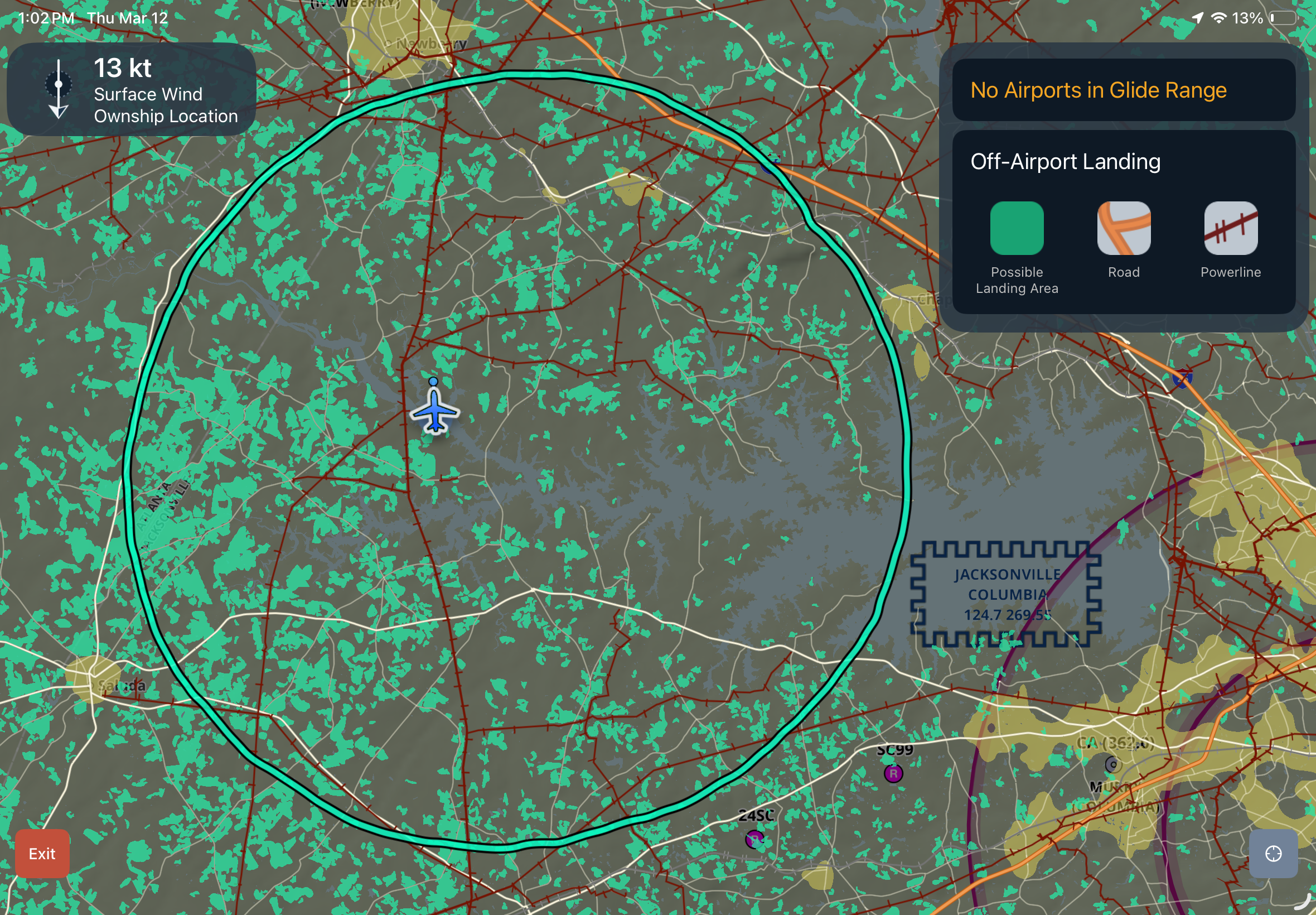
Called Emergency Glide Mode, the tool is designed to provide rapid decision support during one of aviation’s most time-critical scenarios. When activated, it analyzes the aircraft’s position and estimated glide performance to identify reachable airports, runways, and potential off-airport landing sites, then highlights the best options on the moving map.
ForeFlight said the feature is intended to reduce cockpit workload when pilots may be simultaneously managing aircraft control, emergency checklists, communications, and navigation. Instead of manually estimating glide range or searching charts, pilots receive a real-time visual display of available landing choices.
The system also considers terrain and surrounding geography when calculating options, helping pilots determine whether a runway is realistically within reach. If no airport can be made, the software shifts to possible forced-landing sites.
ForeFlight said the feature uses a proprietary algorithm combined with U.S. Geological Survey data to generate detailed maps of potential emergency landing areas. Candidate sites must offer at least 1,000 feet of usable length and are evaluated for terrain, slope, obstacles, nearby hazards such as power lines, and tree cover.
Emergency Glide Mode can also automatically load best-glide speed and glide-ratio data for many aircraft types, while allowing pilots to customize settings for their specific airplane.


Garmin Pilot has had glide range rings and an Emergency mode for many, many years. One enters the glide speed and glide ratio for the aircraft and has a slider to adjust . Airports in the area are highlighted with distance and relative direction listed. Choosing an airport to glide to then sets up direct navigation to it and lists the heading and distance on the map. One also sets up a minimum runway length to be displayed on the map in case of emergency. The Emergency mode also pulls up the emergency checklists in a separate panel.
Glad to see that ForeFlight added their emergency glide mode for all subscription levels. I’m a subscriber to FF as well as GP. Watched the video about it with upgrading to the newest version. FF’s version also shows “best bet” off-airport landing areas using USGS data and takes into account weather in highlighting possible airports. It is nice in FF that after selecting the airport it shows you the field height and radio frequencies, though GP does so when you tap one of the airports that that are listed in order of distance. The airport information pop up defaults to winds, best runway for the wind, airport elevation, and weather with frequencies just a tap away.
Foreflight has had that for years too. This apparently adds in finding off airport areas that are usable as well as some other intelligence. That’s massive at night in wooded areas or IFR/low visibility to get guidance where you at least have a chance of not ending up in the trees.