Airplane Effect Snow’ Dusts O’Hare, Midway

Gemini Sparkle

Key Takeaways:

  • A major airport recently experienced "airplane effect snow," a localized phenomenon creating a dusting over the airport and surrounding area.
  • This rare snow occurs when specific meteorological conditions align: supercooled water droplets in the air combine with soot particles from aircraft engines acting as nuclei.
  • The snow was a light dusting, causing no accumulation or impact on airport operations.
See a mistake? Contact us.

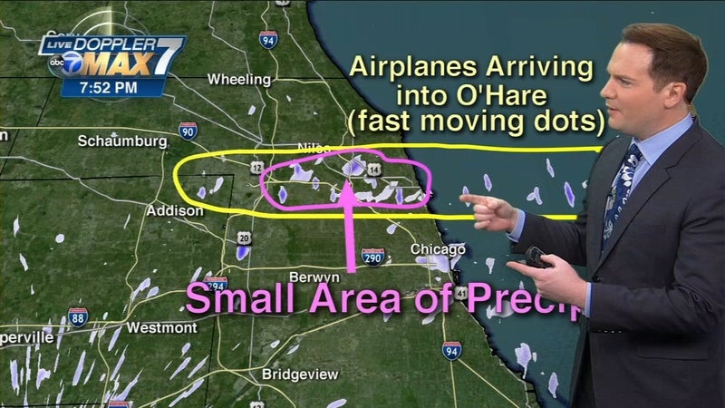
The world’s sixth busiest airport (by passenger traffic) actually created its own weather last week with a phenomenon known as “airplane effect snow” dropping a dusting of the white stuff over the airport and surrounding area last week. ABC 7 reported that meteorological conditions lined up to create the band of light snow, which affected an oval shaped area stretching from the Lake Michigan shore about 10 miles inland. A few flurries were also reported over Midway Airport about 20 miles south. 

The conditions have to be just right to result in the phenomenon. The temperature was in the low 20s and there was lots of moisture in the air. The water took the form of supercooled droplets, which can remain in the liquid state down to -40 degrees. To form snow, they need a nucleus and the tiny bits of soot coming from aircraft engines can provide that cloud seeding mass. There was no accumulation of snow or impact on operations.

Russ Niles

Russ Niles is Editor-in-Chief of AVweb. He has been a pilot for 30 years and joined AVweb 22 years ago. He and his wife Marni live in southern British Columbia where they also operate a small winery.
Sign-up for newsletters & special offers!

Get the latest stories & special offers delivered directly to your inbox

SUBSCRIBE

Please support AVweb.

It looks like you’re using an ad blocker. Ads keep AVweb free and fund our reporting.
Please whitelist AVweb or continue with ads enabled.