
The NTSB released its preliminary report this week on a May 14 air ambulance accident near Lincoln, New Mexico. The Beech C90, operated by Generations Jets to pick up a patient for transport, was destroyed after impacting terrain during a Part 135 flight from Roswell to Ruidoso. Both pilots and two flight nurses were killed.
GPS Reports And Vectors
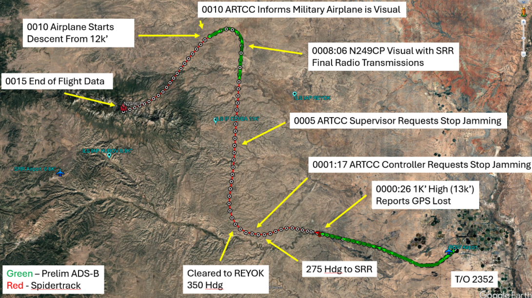
After departing Roswell about 11:52 p.m. on May 13, the crew contacted Albuquerque Center and requested an IFR clearance to Sierra Blanca. At 12:00 a.m., the controller advised the crew that the airplane was at 13,000 feet MSL, 1,000 feet above its assigned altitude, and the pilot replied that the airplane had lost GPS capability and needed a heading. Controllers then provided headings toward Sierra Blanca, while the crew changed its requested approach from the RNAV Runway 24 to the ILS after reporting the GPS problem.
About a minute after the GPS report, a controller contacted an operations supervisor and asked that the military stop conducting a nearby jamming operation. During the same portion of the flight, three other aircraft reported a loss of GPS, and one required additional help identifying a ground-based navigation aid.
Flight tracking data from Spidertracks and ADS-B generally aligned, though the NTSB said in the report that Spidertracks GPS altitudes were about 600 feet higher than ADS-B altitudes and ADS-B returns had large gaps.
Visual Approach
At about 12:08 a.m., while roughly 31 miles northeast of Sierra Blanca, the crew reported seeing Ruidoso and said they could proceed visually. Albuquerque Center cleared the flight to Sierra Blanca for a visual approach, and the crew responded that it would cancel IFR shortly.
No further radio calls were received from the airplane. Soon after, the aircraft turned southwest toward the airport, began descending and later climbed from about 9,400 feet to the final Spidertracks point at 9,823 feet GPS altitude. Wreckage was found at about 9,950 feet, about 730 feet east of the Capitan Mountains Summit Radio Facility. A post-impact fire started a forest fire.
NOTAMs And Airport Information
ForeFlight briefing materials reviewed by investigators included NOTAMs showing Sierra Blanca’s automated weather system was out of service and warning that GPS, including WAAS, GBAS and ADS-B, might not be available in the area during the accident flight. According to the NTSB, the briefing also showed no METAR or TAF for Sierra Blanca. Both published instrument approaches to Runway 24 include a note stating the procedures are not authorized when the local altimeter setting is not received.


Another article i read regarding this accident was that this flight was done on a moonless night. Going in with the knowledge of the different reporting systems down, and GPS issues, i don’t know why the flight continues.
If the crew had visual, the GPS data is a backup. They continued into a bad situation and didn’t break the accident chain. Maybe we are getting way to reliant on automation and not flying the aircraft.
Sad.
Seems that despite heading from ATC the crew lost track of where they were so descended into high terrain before nearing airport. (Airport is at 6814 feet, mountains nearby go to 10,201 ft, they hit at 9,950.)
(Note general area has restricted US military facility popularly known as ‘Area 51’.)
During the 1980s, I flew from California to the midwest and back 3 or four times. Twice to Oshkosh Airventure. LORAN C was in operation and I loved it; and ILS equivalent track to continually follow. The military can shut down parts the US GPS system with an hours notice; which makes it hardly useable. It is time to turn over the GPS system to the US Coast Guard and bring back LORAN C; and tell the Avionics manufacturers where they can go; since they are the ones who got the US Congress to get rid of LORAN C. Life working in reverse with GPS manufacturers; and the US Congress was listening to these GPS manfacture assholes; and thinking like use in autos; which is never a possibility with small aircraft. The rest of the planet still uses LORAN C; that should be message to the US Congress and the GPS manufacturers that they made a mistake and should fix it by bringing back LORAN C. Or, reactivating the LORAN C stations on each coast and in the center of the US will fix the problem. Aircraft owners can go over seas to find their new LORAN C receiver.
Groom Lake, NV (Area 51) is only 631 miles and two states away …
Thanks for the information.
Yes, ground-based low frequency is a good concept for backup.
Station equipment needs updating - ‘e-LORAN’, which is also more versatile because of how it determines position.
There is a proposal for an alternative space system, more precise than GPS but still with much of the vulnerability of GPS I expect.
A few years ago there was a ground system for local use such as surveying.
I note that modern avionics technology facilitates Loran being a single card slotted into a multi-purpose receiver in an airliner.
.