
















image: Washington Post
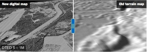
Pilots may presume that we now have access to accurate terrain maps nationwide, but in some remote areas, maps may be based on incomplete data or inaccurate observations that are decades old. “Mars is better mapped than the state of Alaska,” Steve Colligan, president of E-Terra, an Anchorage mapping firm, told The Washington Post recently. Fatal accidents have been blamed on a lack of accurate terrain data that could have made a difference to pilots caught in changing weather in the mountains. Now the U.S. Geological Survey is leading an effort called the 3D Elevation Program, with the aim to chart all 50 states using state-of-the-art, accurate technology — airborne lasers (lidar) or radar (ifsar).
The lidar (light detection and ranging) data and interferometric synthetic aperture radar (ifsar) data make it possible for the USGS to construct accurate 3-D terrain maps. “It’s not an image; it’s data,” Kevin Gallagher, associate director for USGS Core Science Systems, told the Post. “That’s what makes it so powerful. Lidar is like looking at the world through a new set of glasses.” The project to collect all the needed data has run into funding obstacles, the Post reports. The effort to map Alaska started in 2010, but it’s only about half done. High-quality lidar data is available for only about 4 percent of the U.S., according to the USGS. The agency estimates it would take eight years to collect data for the entire country.