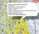
 ince we wrote about ChartGeek in this week’s AVwebBiz, we’ve heard from an AVweb reader who uses a site called RunwayFinder.com, also based on Google Maps. This site doesn’t have the cool 3-D graphics that ChartGeek has developed, but it’s free to all comers. Pilots can zoom in to an airport and check out the runway layouts (as they appeared at the last Google satellite update, which can be several years old). Airspace boundaries and other info from the latest sectional and terminal area charts are laid out seamlessly in their proper locations on the map surface. Each airport also displays recent weather reports. Multiple disclaimers note that the site is not for navigation, but it can still be a useful flight-planning tool. Users can choose to view the area in chart form, as a satellite image, or in terrain mode. In addition, routes and range circles can be plotted.
The site developer, Dave Parsons, accepts PayPal donations from users of the site, which he says will be used for continuing improvements.